| Caribbean Leeward Antilles Map |
|
|
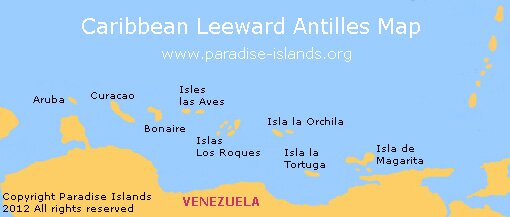
The West Indies encompasses more than five thousand islands. This section of the guide concentrates exclusively on travelling in the Leeward Antilles region of the Caribbean which is situated in the southern area of the Caribbean Sea just above Venezuela.
The Leeward Antilles are divided into two groups of islands; the Dutch "ABC" islands of Aruba, Bonaire and Curacao; and the Venezuelan islands of Las Aves, Los Roques, Orchila, Tortuga and Magarita. |
|
|
This small chain of Islands form the southerly boundary of the Lesser Antilles and were part of what was commonly known as the Netherlands Antilles until they were disbanded in 2010. Sometimes confused with the Leeward Islands to the northeast due to a similar name, it will probably be many years before the name "Netherlands Antilles" is dropped from maps of the region.
The islands of the Leeward Antilles are mostly coral and fairly flat with little volcanic activity. They lie on the southern boundary of the Caribbean Plate which is slowly moving towards and under the South American Plate. |
|
|
|
|
|
|
|
|
|