Want to use this Caribbean Greater Antilles map? Paradise Islands grants permission for this map of the Greater Antilles to be copied or downloaded for personal use or for school projects without requesting permission from the copyright owner. Paradise Islands does not grant permission for this map of the Greater Antilles to be used for any general and commercial website illustration, within blogs or chat sites (please link to this page or link directly to the JPG image file, see below).
Caribbean Greater Antilles Map copyright Paradise Islands. All rights reserved.
Print? Please click this link for the JPG file (800 x 422 pixels): Caribbean Greater Antilles Map
Link to this page? Please use this URL: http://www.paradise-islands.org/caribbean-greater-antilles-map.htm
Link to the JPG file? Image URL: http://www.paradise-islands.org/greater-antilles/images/greater-antilles-map.jpg
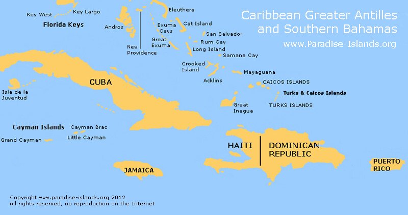
The islands of the Greater Antilles ("Antillas Mayores" in Spanish and "Grandes Antilles" in French) are located in the Caribbean Sea southeast of Florida and south of the Bahamas. The word "Antilles" is derived from the Spanish term "Antillas".
The major Greater Antilles islands are Cuba, Jamaica, Hispaniola island (Haiti and the Dominican Republic) and Puerto Rico. The Cayman Islands are also generally included within the Greater Antilles. The four larger islands represent over ninety percent of the the total land mass of the West Indies (over 200,000 square kilometres) and the same percentage of its population (over 35 million).
The other main Caribbean island group located to the east and south east is known as the Lesser Antilles and split between the Leeward Islands and the Windward Islands. To the north lies the Bahamas and to the south lies the Leeward Antilles including the "Dutch ABC" islands of Aruba, Bonaire and Curacao.
Other Regional Maps: Caribbean | Leeward Islands | Windward Islands | Virgin Islands | USVI | BVI | Lesser Antilles | Bahamas
|

