|
|
|
Welcome to Aruba on the Paradise Islands website. Located in the Leeward Antilles region of the West Indies which is situated in the southern part of the Caribbean Sea just 20 miles north of Venezuela.
There is no rainy season and temperatures typically range between 70 degrees and high 80's Fahrenheit. Positioned far south of the Atlantic hurricane belt, the isle has few tropical storms and dry climate with a sandy desert landscape full of cacti and other drought tolerant plants and trees. |
|

|
|
The official motto is "One happy island" which is on all the car licence plates and the Divi Divi Tree (see image below) is almost a national symbol. The island relies more on tourism than it's neighbours and is geared up for cruise ship passengers with a large mix of American stores, casinos and duty free shops in the main town of Oranjestad. The island's economy is made up of phosphate and gold mining, petroleum and tourism (75% of GDP).
English is widely spoken by the locals (called "Arubans") and US dollars accepted everywhere, despite the Aruban Florin being the official currency.
|
|

|
The Caribbean Leewards Antilles are divided into two groups of isles; the Dutch "ABC" islands of Aruba, Bonaire and Curacao; plus the Venezuelan isles of Los Roques, Las Aves, Isla la Orchila, Tortuga and Magarita. It is the smallest of the "ABC" isles at just 69 square miles.
The ABC islands are commonly known as the Dutch Antilles or the Netherlands Antilles (dissolution in 2010). Aruba, Bonaire, Curacao, St Maarten and Saba are all separate countries or municipalities and form part of the Kingdom of the Netherlands. |
|

|
|
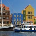
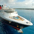
Over one million cruise ship passengers arrive to down town Oranjestad in the Port of Playa every year. The cruise terminal has a tourism information centre and duty free shops and is a five minute walk from the main shopping area and restaurants. The nearest beach (Palm Beach) is a ten / fifteen minute taxi ride from the terminal (taxis do not have meters, fares are set by the Government and displayed on signs in the taxi ranks).
Air passengers arrive at the Queen Beatrix International Airport (Aeropuerto Internacional Reina Beatrix) near Oranjestad. Regular flights arrive and depart from Amsterdam with KLM as well as routes operated by other airlines from Toronto, Princess Juliana Airport on St Maarten and many US cities including New York, Atlanta, Boston and Miami, etc. Over 60% of the 1.7 million annual visitors are US citizens, making Aruba one of the most popular Caribbean destinations for American travellers.
|
| Travel, holiday, vacation and cruise guide to Aruba in the Caribbean Leeward Antilles. All text and images are Copyright Paradise Islands org. All photographs on this website are obtained with the permission of the owners and come from various sources including the island's tourist boards. |
|
|
|
|
|
|
|
|
|
Quick Facts
Capital
Oranjestad
Main Airport
Aeropuerto Internacional Reina Beatrix
Main Port
Playa Terminal
Oranjested
(Cruise Ships)
Language
Dutch
Currency
Aruban Florin
&
US Dollar
Government
Constitutional
Monarchy
Island Size
69 Square Miles
Population
102,000
|
|
|
|
Willemstad Curacao
|
|
|
|
Cruise Port Guide
|
|
|